 |
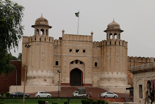
| Lahore Fort |
When crossing from Amritsar at the only land border open to foreigners between India and Pakistan, we were greeted by big smiles and calls of "welcome to Pakistan" from strangers and border officials alike. A short drive took us to Lahore where we spent a couple of days. The monsoon had just arrived so it was both very hot and humid, but we spent a day wandering through the streets of the walled city, and visited the impressive Lahore Fort and the adjacent huge moghul Badshahi Mosque. A most impressive and beautifully proportioned building.
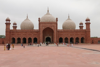 |
| Badshahi Mosque |
With limited time in Pakistan, and wanting to make the most of the mountains, away from the monsoon we headed north towards Islamabad, passing through floodwaters in the streets after a sudden thunderstorm. Cougar Trails in Islamabad offers a refuge for Overlanders with secure parking and a comfortable well equipped room, with all necessary facilities for relaxing.
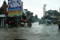 |
| Floodwater on Main highway |
Sanaullah who runs Cougar Trails is incredibly enthusiastic about travelling in Pakistan and was very generous in spending time with us, recommending places to visit in the north. Really useful when there are few available guidebooks, and nothing specific for Overlanders about where to stay etc.
 |
| Kagan Valley |
Setting off north we sped through the lowlands and headed up the beautiful Kagan Valley towards Naran. The Himalaya start to exert their influence with mountains looming wither side of the green valley floor. Recent rainfall had filled many of the side streams with rock debris strewn across the road and small fords to negotiate. Passing Naran, a very busy tourist town packed with Pakistanis on their summer vacation away from the heat of the main cities the road winds up the valley through more rural traditional farming areas to the Babusar Pass at 4180m.
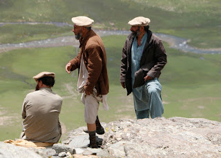 |
| Locals at Babusar Pass |
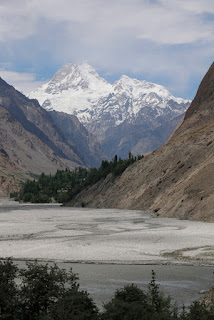
Dropping down through the numerous hairpin bends to the north we joined the famous Karakoram Highway, alongside the Indus River, where we were treated to magnificent view of Nanga Parbat 8126m, one of the most dangerous of the 8000m peaks.
 |
| Nanga Parbat |
The road to Astore climbs a narrow gorge from the Indus, before opening out into a wide and relatively fertile valley nestled between Nanga Parbat and the Deosai mountains. Here we turned off the main road, climbing a steep rubbly road to a beautiful campsite just below Rama Lake. We had the place to ourselves as we walked up to the lake in the morning, being rewarded with a stunning reflection of the 6500m peaks of Chongra, subsidiaries of Nanga Parbat.
The Deosai Plateu on the way to Skardu offers a completely different landscape. Large open and virtually flat areas of grassland are covered in a profusion of wild flowers of all colours. At around 4000m the night sky is crystal clear with brilliant stars and the Milky Way clearly visible.
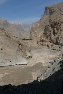
Dropping down into Skardu through an increasingly dry landscape we passed small the beautiful Satpara Lake before arriving in the amazingly large and vibrant town set beside the wide floodplain of the swollen Indus River.
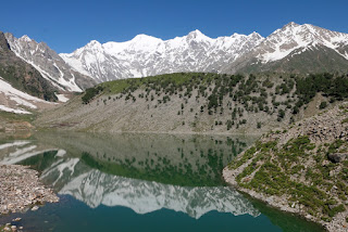 |
| Rama Lake |
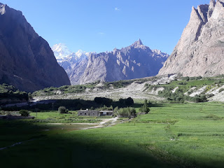
Upstream of Skardu we left the Indus River, and the road to Kargill, just 70kms away in India where we were over a week ago, and followed the Shyok River to Khaplu, an old established small town which boasts one of the oldest mosques and a beautifully restored Fort, really a fortified manor house where the local royal family lived until the 1970's.
With the mountains calling we headed further north towards Hushe. After crossing a very long suspension bridge the valley heads directly towards the beautiful snow covered peak of Masherbrum at 7821m. A stunning drive past near vertical rock walls and glimpses of more high peaks across the valley required a tight several point manoeuver to be able to cross one of the more dynamic suspension bridges - very exciting.
 |
| Masherbrum |
At the top of the valley is Refugio Hotel where we were welcomed by the owners, and where we camped. We made a couple of short walks up the valley through the lush irrigated fields of wheat, barley and peas all loomed over by the high peaks of the Himalaya. Where there is no irrigation the land is desert and rock. While staying four climbers returned after successfully completing ascents of Gasherbrum 8080m and were met with garlands and celebrations. The Refugio Hotel is at the end of the road, and is the closest point to the peaks of K2, Broad Peak and Gasherbrum, all over 8000m high, so is a natural end point of the climbing expeditions.
 |
| Road to Hushe |
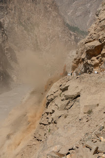
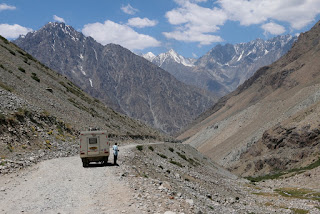
Returning to Skardu we took the road along the Indus Valley towards Gilgit. This road clings to the often vertical sides of the Indus valley, and is currently being widened in an ambitious project to make it two lanes.
 |
| Hushe Valley |
Huge quantities of rock are being blasted and hammered from the hillsides to make room, along the whole 175kms of the road. As a consequence there are frequent delays while blasting occurs, and the road is effectively completely unsurfaced. It took us 15 hours to complete the journey, but the views are incredible.
Joining the beautifully surfaced Karakoram Highway we stopped to view the junction of the Indus and Gilgit Rivers. This point divides the three mountain ranges, The Himalaya, The Karakoram and The Hindu Kush, though few of the mountains can be seen.
 |
| Road Widening |
Gilgit is the main town of the area, though not pretty in itself it is surrounded by mountains and sits beside the Karakoram Highway. The road is now a fast and smooth route with tunnels and scree shelters making easy and fast driving. many Pakistani tourists now drive up to the somewhat unimpressive border with
 |
| Indus Valley |
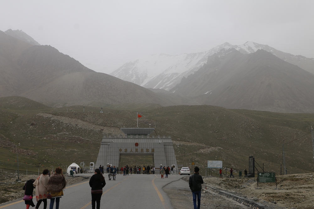
China at the Khunjerab Pass. Pakistan boasts the highest ATM in the world at 4711m, though we did nit test whether it works.
Sanaullah had recommended visiting Pamir Sarai in the Chapursan valley, a guest house run by the knowledgeable, welcoming and fascinating Alam Jan. His stories about expeditions to the Wakhan Corridor and through Afghanistan an entrancing.
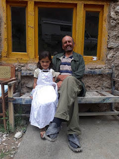 |
| Alum Jan and daughter |
An at times challenging road climbs up the beautiful valley through small villages surrounded by fertile irrigated fields with snow capped peaks on either side. At Parmir Seari we were welcomed into Alam Jan's home where we chatted at length about the Central Asia Institute and his brother's involvement with Greg Mortenson in establishing schools across the north of Pakistan and into Afghanistan.
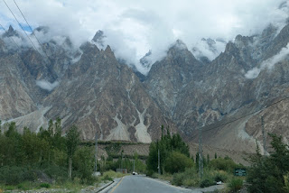 |
| Cathedral Mountains in Hunza Valley |
After a wonderful dinner in his traditional home with his family we had a peaceful night. With the Whakan Corridor just up the valley we drove to the end of the road at the Babu Ghundi shrine.
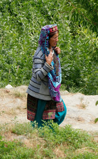 |
| Hunza Traditional costume |
Ant from Australia had spent 10 days chilling and trekking at Pamir Serai, but was ready to move on so we gave him a lift back down to Passau where we planned to take the road to the Shimshal valley, however a landslide the previous day meant the road was blocked for the nest 7 to 10 days so instead we were welcomed to the Passau Peak Inn, opposite the stunning Cathedral Peaks, by the nephew of Alam Jan.
The Hunza Valley is one of the highlights of North Pakistan, and the Karakoram Highway descends through the spectacular scenery. A huge landslide at Attabad in 2010 blocked the Hunza River and destroyed the town of Attabad, creating a large lake which is bypassed by a long tunnel. Petroglyphs just outside Karimabad record the passage of travellers for over 1000 years through this ancient highway, with the stunning restored royal palace at Fort Baltit overlooking the valley.
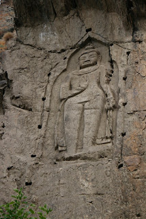 |
| Kargah Buddah |
Back at Gilgit we headed west along the Gilgit River, passing the Kargah Buddah, a first century carved buddah in a high rock face just outside Gilgit. This quiet road follows the river through more beautiful scenery before climbing up to the remote Shandur Polo Ground, at an elevation of 3732m claimed to be the highest polo ground in the world. An annual polo festival is held here every year attended by thousands of enthusiasts.
 |
| Road to Mastuj |
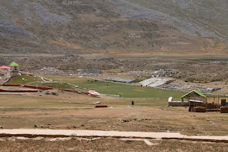 |
| Worlds highest polo ground |
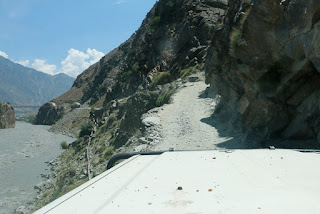
The road deteriorates progressively as it descends to the remote small town of Mastuj, and becomes very interesting as it crosses huge scree slopes and clings to narrow ledges over the river, at times only just wide enough for us to pass. South to Chitral the valley widens with spectacular views of snow clad 6000+m peaks. Passing the rather gloomy town of Chitral we headed for the recommended valley of Bamburait. Despite only being 18kms from the main road the rough, very narrow and low road took 1hr and 30 minutes to negotiate, the last 20 minutes in the dark, so we were relieved to arrive at the PTDC hotel where we could camp.
 |
| Costume of Bamburait |
The inhabitants of the valley have a unique dress and culture, and are believed to be descended from when Alexander the great invaded the area. Such a peaceful location, which had been devastated by a serious flood in 2015 which washed away half the hotel, and many other houses, leaving boulders some 6ft in diameter scattered across the valley bottom.
With only a few days before we need to return to India we headed south and stayed on a beautiful peach farm in the Swat valley - a wide and fertile valley filled with orchards and fields. Niaz and Shujaat are the most welcoming people and have a wonderful camping area and guest facility.
 |
| Will we fit ??? !!! |
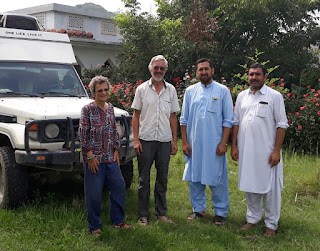 |
| With Niaz and Shujaat at the Peach farm |
They could not do enough for us, providing some of the most delicious food, and helping us with some minor repairs to the van. With our tight timescales it was a shame we could not stay longer.
v


No comments:
Post a Comment